The valley of gardens
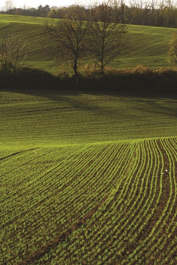
Track goes sometimes underwoods and sometimes through a geen landscape
Description
1- From the car park, take the path along the stadium. Pass through the Combaudon wood (follow the markings) and come out by the buildings. On the right, go up some steps, then turn left to reach a park; cross it and reach a traffic island. Go to the château car park and the post "Le Château".
2- At the bottom of the car park, take a path which goes down towards "Pin Rond". Cross the D41b and take the path that fords the Suze stream. Go up the other side and, via a farm road, reach the hamlet of Chez Meunier; Pass through it, ignoring the accesses on both sides. After an intersection and right turn, reach a trailhead on the left.
3- Leave the road to go along the track through fields. Cross a small road, continuing ahead. Reach the "Pin Rond" junction.
4- Go down by the road and cross the D538. Continue along the road that joins the Suze. After the bridge, turn right onto Chemin de la Suze (about 1.6 km) and go up to the "Le Coin" fork.
> Variant (10.5 km loop, yellow markings).
5- Turn left, Chemin des Frênes, cross the D167 road and pass a farm. Continue on the path on the right and reach the hamlet of Le Coin. Take the road that bends to the left and reach the post "La Cure".
6- Follow the right-hand road (Chemin du Ferrat) to the end. Continue on a trail that climbs to the Le Télégraphe.
7- In the hamlet, turn right into Chemin du Château d'Eau. Cross the D46 and turn right on Route de Vossère, which reaches the hamlet.
8- Continue on the road which goes past orchards.
9- At the beginning of a bend to the left, leave the road for a path to the right which goes down to a housing estate. Continue straight ahead until you reach the D538; cross it, then take an alley on the left. Walk along a wall.
10- At an electricity post, turn right on a road which leads to a path at an old farm. Find a road that heads down and makes a wide turn. Before a bridge, take the dead end on the right. It leads to a track and back to the stadium.
Beware of the various crossings of busy roads, especially the RD502 between circuits no.4 and no.7.
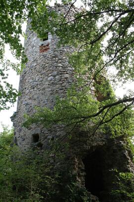
Things to see: the Tower of Montléans and the cup stone.
Opening period
All year round.
Spoken languages
-
 French
 French
Itinerary
- Marked route BALISE
- Route type BOUCLE
- Nature of the land Ground
Equipment
- Picnic area
Services
- Pets welcome
Environments
- In the country
- Village centre
Documents
More informations
Carrefour : Grand Champ
38200